Milton, the 13th named storm of the 2024 Atlantic hurricane season, is churning slowly through the Gulf of Mexico, and it's a near certainty that it will make landfall on the west coast of Florida midweek as a major hurricane, bringing risks of storm surge, heavy rain, flash flooding, and high winds as it moves eastward across the state.
Here in South Florida, the rains have already begun, and forecasts call for the weather to suck at least through Wednesday — perhaps all week long.
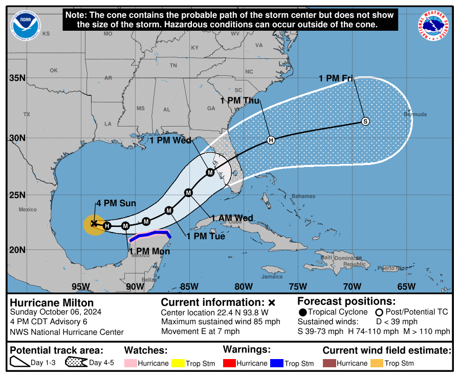
The latest information from the National Hurricane Center (NHC) on Sunday afternoon, October 6, had Milton approaching Mexico's Yucatán Peninsula from the west. From there, the storm is expected to intensify and accelerate as it bears northeast toward the Florida coast.
"[T]he regional hurricane models are showing the system growing even if it weakens, and we are expecting Milton to be a large hurricane at landfall, with very dangerous impacts spread out over a big area. There is increasing confidence that a powerful hurricane with life-threatening hazards will be affecting portions of the Florida west coast around the middle of this week," the NHC warns.
That is what professional journalists call "shitty weather."
While the worst of it might spare South Florida, residents of Miami-Dade and Broward counties should take precautions.
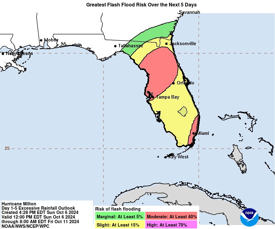
The NHC warns that "heavy rainfall will impact portions of Florida through Monday well ahead of Milton, with heavy rainfall more directly related to Milton expected on Tuesday through Wednesday night. This rainfall will bring the risk of considerable flash, urban, and areal flooding, along with the potential for moderate to major river flooding."
On his Tropical Atlantic Update weather blog, New Times' go-to meteorological expert Brian McNoldy provides additional context.
"The forecasts from the models and NHC have been fairly stable (not varying much from run to run), which continues to paint a dire picture for many parts of already-storm-ravaged western Florida. There is strong agreement on a track toward the central part of the peninsula, with a landfall late Wednesday, and at an intensity of at least a Category 3 hurricane," McNoldy wrote on Sunday afternoon.
"Not only is there relatively light vertical wind shear in the Gulf right now, the water temperature is still record-breaking warm. And it's not just warm in terms of the sea surface temperature, but also through a depth as measured by ocean heat content. High ocean heat content provides a hurricane with a constant source of fuel and makes it much harder to upwell cooler water from below which could weaken the storm. This will help Milton to rapidly intensify and reach a higher peak intensity."
If you have concerns about flooding around your home, the City of Miami and other municipalities have begun distributing sandbags.
This is a breaking news post and will be updated several times per day for as long as weather and other services supply useful information about Hurricane Milton's effect on South Florida.

The rain is here, and it's probably not stopping anytime soon.
Photo by tovifla/Getty Images

Audio By Carbonatix
[
        {
          "name": "Air - MediumRectangle - Inline Content - Mobile Display Size",
          "component": "19274298",
          "insertPoint": "2",
          "requiredCountToDisplay": "2",

          "watchElement": ".fdn-content-body",
          "astAdList": [
            {
              "adType": "rectangle",
              "displayTargets": "mobile"
            }
          ]
        },{
          "name": "Editor Picks",
          "component": "17482312",
          "insertPoint": "4",
          "requiredCountToDisplay": "1",

          "watchElement": ".fdn-content-body",
          "astAdList": [
            {
              "adType": "rectangleLeft",
              "displayTargets": "desktop|tablet"
            },{
              "adType": "rectangleRight",
              "displayTargets": "desktop|tablet|mobile"
            }
          ]
        },{
          "name": "Inline Links",
          "component": "18711090",
          "insertPoint": "8th",
          "startingPoint": 8,
          "requiredCountToDisplay": "7",
          "maxInsertions": 25
        },{
          "name": "Air - MediumRectangle - Combo - Inline Content",
          "component": "17482310",
          "insertPoint": "8th",
          "startingPoint": 8,
          "requiredCountToDisplay": "7",
          "maxInsertions": 25,

          "watchElement": ".fdn-content-body",
          "astAdList": [
            {
              "adType": "rectangleLeft",
              "displayTargets": "desktop|tablet"
            },{
              "adType": "rectangleRight",
              "displayTargets": "desktop|tablet|mobile"
            }
          ]
        },{
          "name": "Inline Links",
          "component": "18711090",
          "insertPoint": "8th",
          "startingPoint": 12,
          "requiredCountToDisplay": "11",
          "maxInsertions": 25
        },{
          "name": "Air - Leaderboard Tower - Combo - Inline Content",
          "component": "17482313",
          "insertPoint": "8th",
          "startingPoint": 12,
          "requiredCountToDisplay": "12",
          "maxInsertions": 25,

          "watchElement": ".fdn-content-body",
          "astAdList": [
            {
              "adType": "leaderboardInlineContent",
              "displayTargets": "desktop|tablet"
            },{
              "adType": "tower",
              "displayTargets": "mobile"
            }
          ]
        }
      ]

BEFORE YOU GO...
Can you help us continue to share our stories? Since the beginning, Miami New Times has been defined as the free, independent voice of Miami — and we'd like to keep it that way. Our members allow us to continue offering readers access to our incisive coverage of local news, food, and culture with no paywalls.
Can you help us continue to share our stories? Since the beginning, Miami New Times has been defined as the free, independent voice of Miami — and we'd like to keep it that way. Our members allow us to continue offering readers access to our incisive coverage of local news, food, and culture with no paywalls.


Trending


Use of this website constitutes acceptance of our
terms of use,
our cookies policy, and our
privacy policy
The Miami New Times may earn a portion of sales from products & services purchased through links on our site from our
affiliate partners.
©2024
Miami New Times, LLC. All rights reserved.
Do Not Sell or Share My Information
Do Not Sell or Share My Information
