Hurricane Beryl defied seasonal norms by strengthening into a catastrophic storm so early in the summer. Intensifying in the Caribbean after tearing through Grenada, the storm's peak wind speed was stronger than that of any other early-July hurricane on record.
The storm weakened before striking Tulum, Mexico, and then made landfall as a Category 1 storm in Texas, where it dropped heavy rainfall and knocked out power to nearly 3 million people this past weekend.
Beryl may be just a taste of what's to come in a hurricane season expected to be hyperactive and nerve-racking for residents in storm-prone areas. With hurricane activity typically peaking in late August to September, the season is still ramping up.
According to a Colorado State University (CSU) report, there is a "well above-average probability for major hurricane landfalls along the continental United States coastline and in the Caribbean." CSU predicts a 31 percent probability that a major hurricane (Category 3 or stronger) will strike the Atlantic coast or Florida peninsula.
"We anticipate an extremely active 2024 hurricane season in the Atlantic basin," researchers wrote.
Senior research scientist Phil Klotzbach and his team at CSU predict around 25 named storms, with 12 reaching hurricane strength and six becoming major hurricanes this season.
CSU researchers noted that warmer than normal sea surface temperatures in the Atlantic and Caribbean are poised to fuel tropical cyclone development. Beryl's rapid intensification bodes in favor of a busy storm season, the report says.
"While early season storm activity in the western Atlantic typically has little relationship with overall basinwide activity, deep tropical hurricane activity in the tropical Atlantic and eastern Caribbean (such as we saw with Beryl) is often associated with hyperactive seasons," the CSU report reads.
For the entire continental U.S. coastline, the report predicts a 57 percent chance of a major hurricane landfall. For the Gulf Coast, which the report defines as the area north of Cedar Key, Florida, stretching to Texas, researchers peg the chances of a major hurricane strike at 38 percent.
The presence of the climatic pattern known as La Niña could provide further favorable conditions for strong hurricane formation. Vertical wind shear that ordinarily weakens tropical cyclones is decreased by La Niña, meaning tropical storms can more easily intensify.
CSU's forecast is at the upper range of the widely watched forecast from the National Oceanographic and Atmospheric Administration. NOAA predicted a significantly "above-normal" season with 17 to 25 total named storms, four to seven of which the agency forecast to become Category 3 or stronger hurricanes.
CSU's new report marks a small increase in predicted storm activity as compared to the university's previous forecast from early June, which projected 23 named storms, 11 hurricanes, and six major hurricanes.
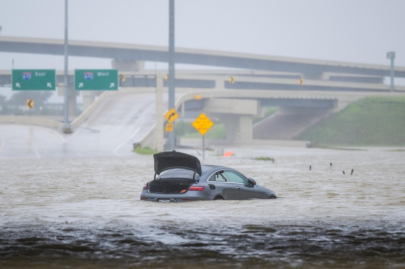
A vehicle abandoned in floodwater after Hurricane Beryl struck Houston on July 8, 2024.
Photo by Brandon Bell/Getty Images

Audio By Carbonatix
[
        {
          "name": "Air - MediumRectangle - Inline Content - Mobile Display Size",
          "component": "19274298",
          "insertPoint": "2",
          "requiredCountToDisplay": "2",

          "watchElement": ".fdn-content-body",
          "astAdList": [
            {
              "adType": "rectangle",
              "displayTargets": "mobile"
            }
          ]
        },{
          "name": "Editor Picks",
          "component": "17482312",
          "insertPoint": "4",
          "requiredCountToDisplay": "1",

          "watchElement": ".fdn-content-body",
          "astAdList": [
            {
              "adType": "rectangle",
              "displayTargets": "desktop|tablet"
            },{
              "adType": "rectangle",
              "displayTargets": "desktop|tablet|mobile"
            }
          ]
        },{
          "name": "Inline Links",
          "component": "18711090",
          "insertPoint": "8th",
          "startingPoint": 8,
          "requiredCountToDisplay": "7",
          "maxInsertions": 25
        },{
          "name": "Air - MediumRectangle - Combo - Inline Content",
          "component": "17482310",
          "insertPoint": "8th",
          "startingPoint": 8,
          "requiredCountToDisplay": "7",
          "maxInsertions": 25,

          "watchElement": ".fdn-content-body",
          "astAdList": [
            {
              "adType": "rectangle",
              "displayTargets": "desktop|tablet"
            },{
              "adType": "rectangle",
              "displayTargets": "desktop|tablet|mobile"
            }
          ]
        },{
          "name": "Inline Links",
          "component": "18711090",
          "insertPoint": "8th",
          "startingPoint": 12,
          "requiredCountToDisplay": "11",
          "maxInsertions": 25
        },{
          "name": "Air - Leaderboard Tower - Combo - Inline Content",
          "component": "17482313",
          "insertPoint": "8th",
          "startingPoint": 12,
          "requiredCountToDisplay": "12",
          "maxInsertions": 25,

          "watchElement": ".fdn-content-body",
          "astAdList": [
            {
              "adType": "leaderboardInlineContent",
              "displayTargets": "desktop|tablet"
            },{
              "adType": "tower",
              "displayTargets": "mobile"
            }
          ]
        }
      ]

BEFORE YOU GO...
Can you help us continue to share our stories? Since the beginning, Miami New Times has been defined as the free, independent voice of Miami — and we'd like to keep it that way. Our members allow us to continue offering readers access to our incisive coverage of local news, food, and culture with no paywalls.
Can you help us continue to share our stories? Since the beginning, Miami New Times has been defined as the free, independent voice of Miami — and we'd like to keep it that way. Our members allow us to continue offering readers access to our incisive coverage of local news, food, and culture with no paywalls.

Trending


Use of this website constitutes acceptance of our
terms of use,
our cookies policy, and our
privacy policy
The Miami New Times may earn a portion of sales from products & services purchased through links on our site from our
affiliate partners.
©2024
Miami New Times, LLC. All rights reserved.
Do Not Sell or Share My Information
Do Not Sell or Share My Information
