The last time the Atlantic saw an inactive August was 1997. Since then, the start of the school year has been marked by at least one storm strong enough to earn a name (i.e., one with winds that reach at least 39 mph).
While we appear to be on the brink of breaking that 24-year run, meteorologists are monitoring two tropical disturbances in the Atlantic that may rain on the record parade. One is forming just off the coast of Senegal in West Africa, while the other is organizing closer to the Americas, east of the Lesser Antilles.
A tropical disturbance is a weather system that migrates within the tropics and keeps its form for 24 hours or more, giving it the potential to become a more intense storm.Tropics update: We now just have two tropical disturbances to watch in the Atlantic. One has a high chance of development and the other has a medium chance. These will stay out in the Atlantic. Danielle is the next name if one becomes a tropical storm. pic.twitter.com/m13oNojyti
— Kyle Hanson (@Kyle_WPMI) August 30, 2022
As of this morning, the nearer of the two disturbances in the Atlantic has an 80 percent chance to develop into a tropical storm. The next named storm to form will be christened "Danielle."
Even if we get through August without a major weather event, we're nowhere near out of this hurricane season's figurative woods.TROPICS UPDATE: Good Monday morning on the anniversary of Hurricane Ida. The central Atlantic wave has a high chance of becoming Tropical Storm Danielle. pic.twitter.com/0woJemnbY1
— Jared Silverman (@JaredWAFB) August 29, 2022
According to the National Oceanic and Atmospheric Administration (NOAA), the most active period of the Atlantic hurricane season kicks off around mid-August and sticks around until mid-October.
A graph from NOAA using data from Atlantic hurricane seasons from 1944 to 2020 shows that the U.S. East Coast's seasonal peak arrives in early to mid-September.
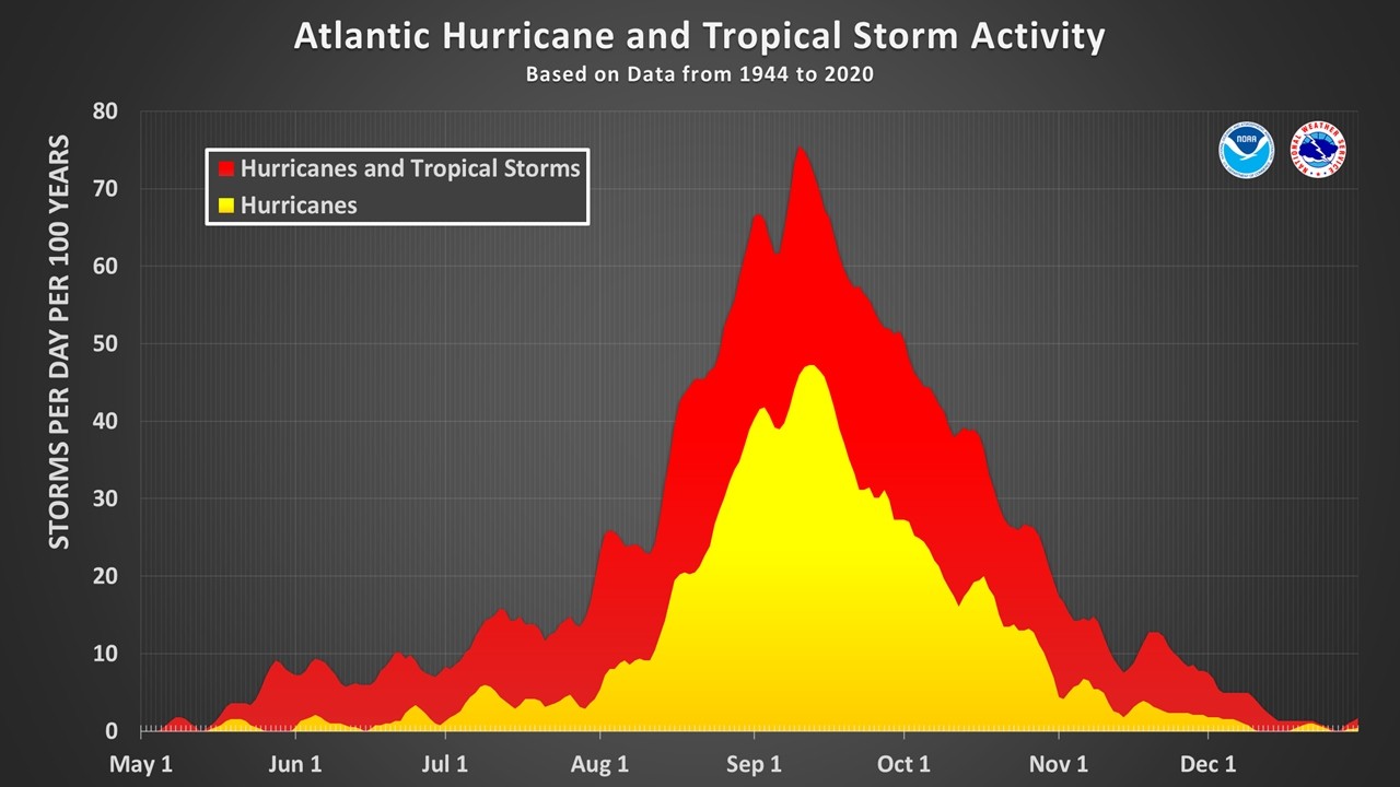
Don't be fooled: This graph may resemble a cozy campfire, but its message is far wetter and less fun.
Screenshot via National Oceanic and Atmospheric Administration
And though we don't have a handy chart to prove it, in our experience, blue skies are the best time to avoid long lines at Home Depot and Walmart.
Miami-Dade County offers a hurricane kit checklist with a list of supplies you should have on hand in the event of a major storm, including seven days worth of water and nonperishable food. The county's hurricane readiness site also provides maps of storm surge zones and guides explaining how to safely evacuate if worse comes to worst.