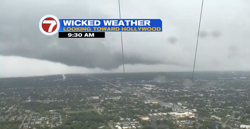
WSVN meteorologist Jackson Dill posted video of the supercell tracking north toward Hollywood as severe weather warnings poured in from Naples to Port St. Lucie to Miami.
According to the National Weather Service, a supercell is one of the rarest types of thunderstorms, capable of producing large hail, destructive winds, and tornadoes. Most common in the central U.S., supercell storms can last up to several hours and travel dozens of miles.
Other supercell activity reported Wednesday in South Florida included a system in Broward that passed over I-75 before noon and generated a tornado warning.
Supercells are characterized by columns of rotation around a central axis stretching up to the clouds. They are responsible for most of the dangerous tornado activity in the U.S.
"This rotation is derived from shear in the environmental wind field (that is, a change in wind direction and/or speed with height) surrounding the storm as it begins to grow," the National Weather Service explains.
South Florida's torrential rain has been wreaking havoc at Miami International Airport and putting communities at risk of flooding from coast-to-cast in the Sunshine State. On Tuesday night, Sarasota had record single-hour rainfall of around 4 inches.Cool view of this rotation of a supercell thunderstorm rapidly tracking north in this view looking north toward Hollywood! #FLwx pic.twitter.com/f7N2pxGG1p
— Jackson Dill (@Jackson_Dill) June 12, 2024
The National Weather Service Miami office said that while the "main concern" Wednesday is urban and flash flooding, forecasters cannot rule out isolated tornados. A flood watch was in effect for all of South Florida until Thursday evening.
After some areas of Miami saw an estimated six inches of rain, the deluge is expected to continue and potentially bring the rainfall total to 10 inches by Thursday afternoon.
Thunderstorms are forecast to persist throughout the remainder of the week, extending into Sunday and potentially stretching into the following week. After a relatively dry May and weeks of stagnant sunshine, Floridians are preparing for a gloomy cycle of thunder and rainfall in the coming June days.